Death Stranding

Last weekend, I finished playing Death Stranding. It’s a strange game, and sometimes frustrating – not least for the ending: 40 hours of play was rewarded with hours of cut scenes to explain the plot. Still, now I’ve completed the main story, I can focus on the bits I like – making deliveries and connecting preppers to the chiral network.

Death Stranding is a game about deliveries, about taking parcels between isolated people who are unable to leave their homes. Yes, for a game released in November 2019, just before the first confirmed case of coronavirus, it’s weirdly prescient. During March, I actually spent time in the real world dropping off food and medication to people who were shielding.

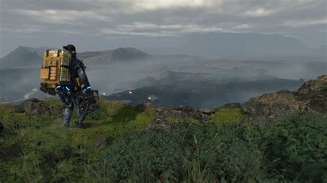
My biggest frustration was with how the game shifted genre. I wanted to play a game about building and connecting, and resented being forced to pick up guns to fight people and bosses. I was at my happiest making long, lonely hikes across mountains. One of the big criticisms I’ve seen of this game is that it is simply a ‘walking simulator’. I cannot underplay how wonderful I found the portrayal of walking. It felt very close to my personal experience of hiking over rough terrain and picking the best route.

The other great thing about the game was its asynchronous multiplayer elements. You can use infrastructure created by other players and are rewarded when they use elements that you have created. I’m not quite sure how it works, but it’s fun and effective. I do wonder how this will work as the game ages. Will these connections decay as players move away and, eventually, the servers are switched off? This would be a tragedy.

One surprising thing was how traumatic some of the game’s themes were, featuring bereavement, miscarriage and mourning. It wasn’t exploitative, but it can’t be easy for everyone to deal with. In addition, after Anita Sarkeesian’s excellent work on Tropes in Gaming, it was disappointing to see a female characters made sexually vulnerable to add jeopardy.

But the game sticks with me. As I played, I found myself thinking about incomplete deliveries the morning after a session. I felt acutely the incompetence when I arrived at one destination to realise that I’d left the cargo behind.

I’ve had a week off the game, but I’m planning to return to the world of Death Stranding. I may have completed the main story, but the game allows you to continue making deliveries and building infrastructure. I’m looking forward to heading back into the mountains and visiting some of the places I missed first time round.

A Mysterious Tile, in the Wrong Place

Image from Wikipedia

TOYNBEE IDEA IN MOVIE 2001 RESURRECT DEAD ON PLANET JUPITER

The phase turned up on mysterious tiles placed in American cities in the 80s and 90s. Nobody is entirely certain where they came from. I’m sure I remember seeing some in New York, when I was living near Manhattan in 1999. That’s not impossible as some Toynbee tiles were placed in New York, but I didn’t have a digital camera back then to record the odd things I saw.

The Toynbee tiles are discussed in books like The Mysterium and were featured in Atlas Obscura. Both of these sources dig into the origin of the message, with its references to 2001 and, possibly, Ray Bradbury’s story The Toynbee Convector (some of the later tiles also contained anti-semitic paranoia). The 2011 documentary Resurrect Dead: The Mystery of the Toynbee Tiles came up with an explanation of how they were placed, using a car with a hole in the passenger-side floor.

The Atlas Obscura story is a great summary of what is known, as well as more recent appearances of these tiles, in the middle of the last decade. It’s a fascinating story, and you can imagine how surprised to see one of these tiles in Sussex, on my last walk before lockdown 1. This was on the road from Firle Beacon down toward the village:

I wondered what this was doing so far from home. It seems to read “D_ B____ says fish will fall from sky”, which I guess means it was a promotion for the Mysterium book. Good to see that it is still around, ready to confuse passing hikers.

Video Games vs Reality

I used to have a friend that loved getting high and playing video games. They were obsessed with 1993’s Doom, an early first-person shooter which had relentless waves of enemies and an odd ‘forced 3D’.

Sometimes, you’d be in a place with them and they would compare it to a Doom level. It always felt jarring – I understood that the impression was vivid to them, but it didn’t translate to other people. When I was in the Louvre, I was amazed by the art, not how easily I could imagine a Cyberdemon appearing from around the corner.

Last month, I was climbing a hill in Shropshire, walking over scrub common-land, with clouds drawing down closer. There was no real path so I had to pick the best route. As I climbed, I looked up to see some ruined buildings emerged in the shadows ahead of me.

And I couldn’t help but feeling like I was in the game Death Stranding.

I played a lot of Doom and Quake back in the nineties, but I’d never had such a strong feeling of deja-vu about a game before. It’s something to do with how sophisticated these games have become. When I’m walking through the landscape in Death Stranding, it feels so similar to keeping my balance when I’m walking on steep hills. And the distance between reality and graphics is diminishing, particularly on misty days.

A week ago, I spent an entire day playing The Last of Us Part 2 (hey, it’s a pandemic). When I went out to the supermarket afterwards, my movements felt videogame-like, my vision when I turned like the in-game camera. When I picked things up to put them in my pocket, I felt the same satisfying click as that game provided.

I’d like to argue that this is more remarkable than simply seeing long corridors and hidden corners as dangerous; but I reckon I was unfair to this friend. They’d just engaged with games more intently than I had.

A 23-minute pilgrimage

A few weeks ago I was emailed the following instructions:

You are invited to make a Pilgrimage on 12/11/20.
To where and what is up to you.
Choose a place or let one choose you.
Make the pilgrimage only 23 minutes long.
At the end of your Pilgrimage, create a small ritual of completion.
Film a 23 second video sharing whatever feels right.
Post it online at 7.23pm.
Best of luck. xx

The route I chose for my pilgrimage was along the Hove Promenade. It was not exactly 23 minutes, but it was near enough. As I walked, I recalled the CERN pilgrimage from Easter 2019. I carried some of my pilgrimage relics with me, including cards from the tarot deck designed for the trip.

In her book on Banaras, Diana Eck writes about how “The symbol that condenses the whole into the part is common in the Hindu world”. One of the holiest pilgrimages in Hinduism is to visit the Char Dhams, a trip to four sacred sites in the different corners of India. According to some, the same benefits can be attained through a certain 5-day pilgrimage on the Panchakroshi Road, which encircles Kashi. The same pilgrimage in different places, at different scales. In a similar way, I wanted my 23-minute pilgrimage to condense that longer pilgrimage from last year.

So many memories returned on my walk. Sika Deer. Delaying to eat food before heading to the ferry. The Bricklayer running the Pilgrim Opera rehearsals. The machines at the CERN museum – and the world’s first web server. The Lion’s valiant work to stitch the dress for the ritual. Getting a group of pilgrims lost in Switzerland looking for the restaurant.

I ended my pilgrimage on a manhole cover, the very same one from Mathew Street in Liverpool. Like the single electron travelling back and forth in time through our universe, this manhole exists in many places simultaneously. This manhole in Hove is now connected to a strand of the inter-stellar Ley line.

A River Walk (Lewes to Peacehaven)

I’m not a huge fan of riverside hikes. I hate how a long stretch of walking beside a meandering river covers so little distance. Despite that, when some friends suggested a walk along the Ouse I decided to join them.

I took my first trip on a train since March. The train station was strange and oppressive, and also very quiet. We set out for the Ouse via the ruins of Lewes Priory.

We’d started out early, but the heat was already brutal. I kept slathering on the suncream and went through my drinks faster than planned (last night I ordered a couple more aluminium bottles ready for future hikes this summer). Waterbirds darted about and, on the opposite bank were a menacing line of cows, the young ones sheltering in their parent’s shadows.

The landscape south of Lewes is beautiful, with views of Firle Beacon, Mount Caburn and Lewes castle. And, while the river was taking long loops it didn’t feel too irritating. As Frankie pointed out, it meant our view of the scenery kept changing. The route was more interesting than the equivalent section of the South Downs Way, where you have the same ridge of the hill ahead of you for hours.

We did walk a tiny section of the South Downs way when we met it at the Southease swing-bridge. We walked from one side of the bridge to the other than back to continue our journey along the Ouse’s west bank.

On the east side of the river, we found a short trail of muddy hoof prints.

We couldn’t follow the banks of the Ouse the whole way, since private property forced us inland near Piddinghoe. Instead we had to follow a fast stretch of road with little pavement – but at least it gave us some shade.

The river was very low and, in the end, only one of us took a dip. I sat on a bench and enjoyed the view of Itford Hill.

For some miles, we’d seen thick smoke rising from Newhaven. At Piddinghoe we encountered a couple of walkers who’d left the town for the day to avoid this cloud. When the wind changed for a time we could see and smell the smoke, so we decided to change our plan of heading to Newhaven and strike out south-west for Peacehaven.

There was a path clearly marked on the OS map, so we took that for it. I learned a useful lesson: just because a path is clearly marked, it doesn’t make it easy to navigate. This one was thick with brambles, some of which drew blood from Frankie’s legs. The branches were also thick with fruit, which I guess is a fair exchange, and Frankie emerged with an armful of forage. The hedge beside us was also full of butterflies.

The difficult part of the route did not last too long, but it was definitely one of those neglected paths which seem to have been actively made unwelcoming. The footpath was actually blocked at one point by a low fence.

But we did have some great views on our way to Peacehaven’s Centenary Park, from where we headed to the the meridien marker before taking an Uber home. It was a good day out, and walks in company are generally much more fun that solitiary ones – I even learned about how PCR testing works. And I managed to add another 10 meters towards my re-walking of the South Downs Way.

Hiking the South Downs Way 1: Belle Tout Lighthouse to Alfriston

After very little recent hiking (my last proper walk was June 20th), it was good to get out again. Even on the day itself, it was hard to leave the safety of my nest, but worth it once I was out. I’m hoping to walk the whole of the South Downs Way in August/September, so this 9 mile section was a good start.

Obviously, the Belle Tout lighthouse is not a traditional starting point for the South Downs Way. Katharine thought the trail started from Beachy Head, and I thought she wanted to keep the distance down. Either way, we will have to come back and do that missing three mile section. It’s an opportunity for me to walk the Jevington route, the alternative path for cyclists.

The weather was pretty much perfect for hiking – sunny but breezy, not too hot. My fitness wasn’t so good – I had to rest a few times when climbing the seven sisters. I’ve also developed a bad back during lockdown, and fell over when I slipped on one of the downhill sections.

But the white cliffs were stunning and we even had a flyby from a couple of spitfires, which performed acrobatics above Beachy Head.

At the end of the Seven Sisters was Cuckmere Haven. I recently read about how the valley was once filled with defences to resist the planned German invasion. From there we walked through Friston Forest through to Litlington, where Katharine spotted a turn I blithely missed. From there, we strolled the meadows leading to Alfriston, where we had lunch before heading home.

But, before leaving Alfriston, we popped into Much Ado Books. My first trip to an actual bookshop in months, but they made the whole thing friendly rather than weird. I ended up buying a couple of books, one on foraging, and one I couldn’t resist for the title, The Museum of Whales You Will Never See: And Other Excursions to Iceland’s Most Unusual Museums. I’ve been buying from that virtual bookshop recently, and I’d forgotten the joys of a proper bookshop.

The bookshop was giving out vintage postcards with all purchases, so I now have a lovely postcard of Budapest to send to someone. Also, usefully, there was a chart to help you see which authors are the same size as you.

After weeks without a proper hike, it was good to get out again. Katharine had been feeling the same frustrations as me about walking alone. We talked about old friends, future plans and our fears. The best conversations happen when hiking. Next up, we need to book in the Winchester leg.

The Peaks of Brighton

I’ve always been a little jealous of people with the time and location to collect Munros and Wainwrights. All the interesting climbs in Britain are some distance from the south coast. The chalk geology of Sussex does not lead to exciting peaks – the highest point is a mere 280m, at Blackdown. I mean, it’s better than Essex (highest point 147m) or Norfolk (103m), but it’s not much.

In November 2017, the Brighton Urban Ramblers did a City Three Peaks, but they went for steepest streets rather than highest points, picking Dyke Road, Preston Drove, and Southover Street. Still, there are high points in Sussex, which means they can be collected.

There is a list of Brighton Hills in Tim Carder’s Encylopedia of Brighton which is reproduced on My Brighton and Hove, although the heights are given in feet. Taking an arbitrary cut-off at 100m, the ‘peaks’ within the borough are:

  1. 645 Bullock Hill, Woodingdean
  2. 584 Hollingbury, Patcham
  3. 580 Holt Hill, Patcham
  4. 534 Falmer Hill, off Falmer Road
  5. 531 near Pudding Bag Wood, StanmerPark
  6. 510 Varncombe Hill, Patcham
  7. 509 The Bostle, Woodingdean
  8. 503 Heath Hill, Woodingdean
  9. 485 Tegdown Hill, Patcham
  10. 476 on Ditchling Road south of Old Boat Corner
  11. 463 Race Hill, by Bear Road
  12. 435 Scare Hill, Patcham
  13. 430 in Stanmer Great Wood
  14. 430 Red Hill, Westdene
  15. 427 Sweet Hill, Patcham
  16. 417 Race Hill, by the Race Stands
  17. 417 Telscombe Tye, Saltdean
  18. 411 at Balsdean Reservoir
  19. 410 Ewebottom Hill, Patcham
  20. 398 High Hill, Balsdean
  21. 396 Whitehawk Hill, Brighton
  22. 387 Coney Hill, Westdene
  23. 367 Mount Pleasant, Woodingdean
  24. 355 on Dyke Road Avenue, near Dyke Road Place
  25. 352 Red Hill, Roedean
  26. 334 Tenant Hill, Saltdean

That is a lot of hills. I decided that a better starting point would be the trig pillars, since they should have good views and account for Topographic prominence. There is an excellent database of trigpoints at trigpointing.uk, which includes all the trig points around Brighton. Some of these are listed as destroyed, but are still useful target locations. Their catalogue of Brighton trig points includes 6 pillars:

I’m going to take this as the starting point for my ‘Brighton Peak bagging’, although it makes sense to expand this into the wider Brighton Downs – using the arbitrary definition of the area covered by Dave Bang’s book A Freedom to Roam Guide to the Brighton Downs. This would expand the area to cover Beeding Hill through to Lewes, also including the north slope of Clayton Hill and Ditchling Beacon. So far, I’ve done one of the trig points, now I just need to divide the others into a few sensible routes.

Anyone interested in joining me for a session of Brighton peak-bagging?

Back to The Brighton and Hove Way

During Summer, the Brighton Explorer’s Club would normally be off on adventures, but lockdown means looking for excitment closer to home. During June, the group has had teams walking the Brighton and Hove Way.

I walked the entire Brighton and Hove Way in a single day on the May bank holiday. It’s a great trail, although doing in one hot day was hard, brutal work – it turns out the 27km distance listed on the website was a typo, and it’s 27 miles. It’s been more fun split into three sections with a (socially-distanced) group. The team event has been well-organised, with a photography competition as well as a quiz.

So far, our group has done two outings walking the sections between Dyke Road through to Falmer via the seafront, leaving a fun stretch along the Downs at the back of the town as our finial journey.

On my first trip, I complained a little about the GPS trail. The exit from Balsdean was actually more obvious than I realised, as well as more scenic. The section around suburban Portslade was still a little tricky, however. The route’s organisers are working to get funding for signage, but progress is slow.

It’s less than a month since I first walked the route, but the changes are notable, particularly the growing crops and bright poppies month them. It’s also been far more fun walking the trail with company.

On the section near Balsdean, we found this huge lump of quartz. It was about a foot across. I have no idea how it came to be on the path. According to Jim Mellor: “the piece of quartz in the photo from the Brighton and Hove Way could be a ‘salt lick’ – a mineral lump left out for cattle as a diet supplement”

With the grass and crops being taller, the wind causes waves to run across the hills. It’s quite a beautiful effect, which the photograph below only hints at:

Looking back towards Balsdean from the correct path out of the valley, rather than the one I took originally.

It’s always good to see the ‘This Way’ markers about the place.

Running weekly flash-fiction workshops during lockdown

This weekend, on June 13th, I’m running the 8th online (and free) Not for the Faint-Hearted workshop. Signups are available via eventbrite, and if you can’t make this session, you can sign up to our mailing list for future events.

Not for the Faint-Hearted has been running for over ten years at Brighton’s Skiff co-working centre, but the pandemic restrictions have forced us to move online. I’d been planning to experiment with online sessions for ages, but hadn’t got round to it before.

The main difference is that people can attend without needing to be in Brighton (we have had attendees from Italy, Canada and Sweden). It’s also a little more intense running the sessions via zoom, and being attentive to everyone at once. I think they are tiring for the attendees too, so I aim for about an hour of writing and reading, with some time to chat at the end.

The sessions are a lot of fun and worth the effort. Each event has a mix of regulars and new people, and the format seems to translate well to zoom. It’s not perfect – I much prefer the energy from a group writing together in the same room – but it’s a lovely thing to be doing during a bad time. And it’s good to be carrying on the group when so much else has had to be put on hold.

If you’d like to read more about the group’s history and how it works, there’s a piece on this blog. It would be great to have more new people come along. I’m going to keep doing these for the time being, until something life normality is restored.

I’m also thinking about some other means of doing Not for the Faint-Hearted-style workshops, and will testing one of these out on a friend next week.

A Walk to the River Adur

I’ve mentioned recently about how frustrating Brighton is for hiking. We’re not supposed to take public transport unless necessary, so I’m currently confined to hikes that start from my house. There are only so many routes to the Downs within walking distance, all of which involve long stretches of built-up areas.

On the last day in May, rather than setting out West or North, I went West, striking out for Shoreham. This meant a long stretch of walking along low-grade industrial areas. I still found a few surprises, like this poem written on a piece of slate:

I took breakfast at the lighthouse, watching a boat come in, and was in Shoreham itself just before eight, joining the Downs Link Path near the Ropetackle Center.

I’ve talked in the past about how unsatisfying I found the Downs Link. As a former railway line, it’s straight and flat with trees blocking the views on both sides – although I was glad for the shade on this occasion. I imagine it is more fun to cycle the Downs Link than to walk – and there were lots of mountain bikers, some of them giving little quarter to pedestrians.

Near the old cement works, someone had stored the bases from the ornamental snails that had been placed around Brighton a couple of years back:

Walking by the Adur was pleasant. The river turns up in Nick Cave’s song Jesus Alone (You fell from the sky / Crash landed in a field / Near the river Adur / Flowers spring from the ground). The word Adur is also, by coincidence, a concept in Basque magic related to the magic of naming.

At one of the bridges across the Adur, the Downs Link crosses the South Downs Way. I had considered heading further west to Chanctonbury once I reached the South Downs Way, but I wasn’t in the mood for the 3-4 hour round trip, particularly when my big toes were still bruised from the Brighton and Hove Way the week before. Instead, I crossed the A283 and headed up Beeding Hill. I even took my hoodie off, since I’d remembered the sun cream this time. It’s a good little walk, and one I like.

Sometimes I wonder what I get out of these walks. I like the exercise, I like the scenery, but distancing is making me too aware of my familiarity with these paths. Also, the geology of Sussex is so fucking boring. The landscape has none of the interesting features found further North. The need to go out to the same places every weekend is draining some of the joy from walking. And having to walk alone underlines how much more I enjoy the social sides of walking.

At the Youth Hostel, I stop on one of the picnic tables, now placed to block access to the camping area. A couple of men pass on bikes, their stereo loudly playing Eminem, and I try not be be irritated by how they’ve inflicted their choice of music on other people.

The hills bounce towards Devil’s Dyke, and I’m thinking a question raised by a project I’m contributing to: how should writers record walks? There is a lot of writing about walking, some of it very good – The Salt Path is one of my favourite books. But nature writing and accounts of hiking can easily devolve to men wandering about, noticing things. It doesn’t matter how clever the noticings are, it’s still wearing. How do you write about place without devolving into that debased psychogeography which is men writing to show where they’ve been, like dogs pissing on fenceposts?

I wonder if I’m spending too much time by myself. I wonder what type of walking-writing I would most like to read, rather than that I find easiest to write. I have lived my entire life within sight of these hills, bar a few months here and there. Does that matter? Should it matter?