When I told a friend that I was downloading a walk from a blog, he pointed that out I wouldn’t download software from a blog and should be just as careful with route maps.
I had to go walking with Helen because she had a pile of my tents. I had a full car returning from the Port Eliot Festival, so handed off some cargo, which gave us a great excuse for getting together to go hiking. We considered a few different locations, finally settling on a walk near the Devil’s Punchbowl. With a little research, I found a route on out-of-the-loop.com, The Devil’s Punch Bowl and Surrey Heaths.
We picked the Devil’s Punch Bowl as it was near to Helen, and arranged to meet at Haslemere station, shuffling the cars to leave one at each end. It turns out there is more than one Haslemere and we started the day at different ones – my plan to save driving had not worked out so well. Still, this gave me chance for a second breakfast and we still set off fairly early.
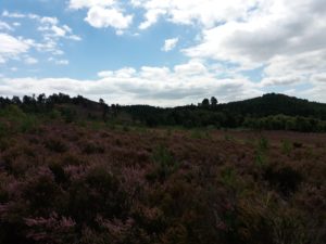
The walk took us from Haslemere Station to Bentley and the scenery, particularly around Frensham, was stunning, with brightly coloured heather moors and scenic hills. We passed fish ponds once owned by the Bishop of Winchester. As I learned at Miranda Kane‘s show Crossbones, the position also used to involve running brothels in London. The reeds at the shore once stood in for the banks of the Nile in the movie The Mummy.
The Devil’s Punch Bowl is a stunning landscape, a natural amphitheatre at the top of a valley. I’d not realised there was landscape this amazing so close to where I live. This site was formed after the devil dug out the Dyke near Brighton. Hearing a cock crowing he leapt from the Dyke, causing the crater when he landed.
This was originally the site of the main London to Portsmouth Road until 2011 when it was re-routed by a tunnel. It’s hard to imagine what this landscape was like before that. Nearby is Gibbet Hill, which was the site of a gallows where tarred bodies were hung in cages as a warning to highwaymen. The site is now marked with a Celtic cross.
It’s possible to look out from Gibbet Hill towards London and, on a fine day (like when we visited), the skyscrapers are visible 41 miles away in the distance. Nearer by, is Box Hill, which I’d visited on the North Downs Way.
And how did the downloaded instructions work? Pretty well. They were published a few years ago and a few landmarks such as noticeboards had disappeared. But we had maps and knew roughly where we were headed so it worked out pretty well. The landscapes were some of the finest I’ve seen in the South East, and I might not have visited without this guide.
Looking at the pictures on the website, they seem to have been taken in winter. It was interesting to see how the seasons affected the directions. Sometimes, the guide described landmarks that weren’t visible from a distance, hidden by the growths of summer.
A good walk, and one that will be worth revisiting in the future.
If you want to follow what I'm up to, sign up to my mailing list


One thought on “A walk to the Devil’s Punchbowl”